Grady to Spanish Fort
Aliases: The yellow Bank Crossing, The Grady Ferry, “Uncle Ed Morris” Ferry,
Wilkes Johnson’s Ferry, Owings’/Owens’ Ferry, and “possibly” Old Spanish Fort Ferry
Seeking photos for our archives
|
The early ferry crossing “below” Grady was not directly south but rather two miles south east just as the river arch begins its descent. The 1898 Chickasaw Nation Map roadway crosses the River at GPS coordinates 33.990991, -97.638803, with Spanish Fort lying three miles directly south. Only two and a half miles around the bend to the south is the ferry from Petersburg to Spanish Fort and the names of the operators often become entwined. (Note: a 1900 Chickasaw Nation Map reflects a roadway crossing the river southwest of Grady at GPS coordinates 33.988585, -97.687135, and does not reflect a crossing southeast of Grady a short distance west of the mouth of Bakers Creek.)
The river could be forded at this location known without confusion as The Yellow Bank Ford or The Yellow Bank Crossing. It served as a fording place in the days of the Chickasaw Nation for both early settlements of Grady 2.5 miles to the northwest and of Petersburg 4 miles southeast. Viola Bigbie’s article in The History of Spanish Fort, pg 9 goes on to say: “Another ferry, the Yellow Bank Crossing was located north of the Allison Hill farm (now Raymond and Linda Frost). A family record of John W. Rich shows he obtained a charter for the ferry in 1879. Mr. Rich died July 21, 1897 and is buried in the Spanish Fort Cemetery. His wife, Sarah Stiles Rich died in 1903 and is buried alongside her husband. Mr. Rich’s son Dick and later Haram Rich and also a Mr. Owens operated the ferries until 1930. These gentlemen were farmers and if they needed to operate the ferry, a large dinner bell was rung to alert them.” I visited on several occasions back in the 1970s with Viola Bigbie and Adrian Hill, two gifted historians from Spanish Fort, as we attempted to “nail down” the ferry locations. There is much more information available today and I believe the Rich Ferry and the Owings Ferry were two separate locations. From The Spanish Fort Series, By Annette “Ann” Rich Weyant, “John Rich raised his grandson Hiram, born in 1884, and Hiram helped operate his grandfather’s ferry”. Frank Driskell was a young boy when his family settled at Courtney Flat Jan 1, 1875, “There was the Yellow Bank ferry crossing: the ferry boat owned and operated by Uncle Ed Morris, that was just south of Grady. Wilkes Johnson owned a ferry boat real close to this one and Jim Owens also ran a ferry boat close to this one.” (IPH int. # 4934 Frank Driskell) Upon first reading of Driskell’s account it may appear that there were several adjacent ferries at the same time. Driskell likely was referencing various operators over the years and their exact location may have differed over the years especially as the course of the river fluctuates. Searching census records on both sides of the river there is one Robert “Bob” W. Morris born 1846 in Louisiana and his wife Rhoda and children Wittenhale, Wm, and Laura. Bob and Rhoda Morris reside in Montague from the 1870s until Rhoda’s death in 1918 and Bob Morris’ death in 1921. They are both buried at Spanish Fort. At the time of his death Bob Morris resided with his daughter Mary and her husband C.W. Williams. Could this be “Uncle Bob Morris”, ferry operator? Willie Blair was born 1881 in Texas and was a small girl when her parents moved to the Indian Territory around 1888. “They had two wagons with oxen, Mother drove one and Father drove the other with chair, tubs and lanterns sticking out on all sides. We crossed Red River at Spanish Fort in Montague County Texas which was called Yellow Bank Crossing. This crossing was ferried when the water was up and forded when it was down.” “Father was a white man and at that time had plenty of money. He secured a farm and some stock and by May had an extra good start toward making more money. Then in May a flood came and Red River went all over the farm. There was fourteen feet of water right around our house and two families were on top of the house from eleven o’clock one morning until half-past two o’clock the next afternoon. The water spread three miles in one direction and four miles in the other. Finally a boat came to our rescue and they were brave men in that boat or they would have left us to go on down the river with the stock, chickens and other things. There were no banks in those days so most of our money was washed away too. The only things we had left when the flood was over were the two spans of oxen that were found eight or nine miles down the river after the water receded. Nobody knows whether these oxen kept out of reach of the water or whether the water washed them down the river.”(IPH Int. # 13714 Willie Blair) |
too. The only things we had left when the flood was over were the two spans of oxen that were found eight or nine miles down the river after the water receded. Nobody knows whether these oxen kept out of reach of the water or whether the water washed them down the river.”(IPH Int. # 13714 Willie Blair)
Pioneer Mary Elizabeth Marshall recalled, “…. in 1891 we decided to come to the Territory. When we crossed Red River we crossed at the old Spanish Fort called the Yellow Bank Crossing; we had two wagons drawn by horses. We brought five or six head of extra stock along with us and when we had them on the ferryboat one of the young two year old mares got so scared she broke loose and jumped over the rails of the ferryboat and swam across the river. “ Marshall added that the old Duncan Trail came from Yellow Bank Crossing on Red River to Grady and then on to Duncan. The Yellow Bank crossing could be forded in the early days and that a man named Owens ran a ferry at Grady. She continues, “When we lived at the Roach place [Grady, Chickasaw Nation] the soldiers brought eight or ten families and stopped at our house to get water for them; they would not ask anyone if they could get water for the people and all their stock. The soldiers were taking these people over to the Texas side at the Yellow Bank Crossing, putting them out of the Territory. About the time the soldiers would get them over into Texas the Governor of Texas would order them out of Texas, as they were not wanted there either, so back they would come to the Territory.” (IPH Int. # 9871 Mary Elizabeth Marshall) The course of the river had changed by 1905 and the Yellow Bank Ferry is reflected at GPS coordinates 33.983391, -97.627273. Confusing matters more, at times there seems to be a distinction between “old Spanish Fort” and the ferry crossing at Grady known as Yellow Bank. “Webb Johnson and Bob Morris ran a ferryboat at old Spanish Fort, a man named Ward ran one at Fleetwood and a man named Owens ran a ferry at Grady.” (IPH Int. # 9871 Mary Elizabeth Marshall) The following mortgage record was provided by Max Brown; “Ed Owings, Montague Co., TX grantor to N.J. Honker? Montague Co., TX dated Feb 4 1900 Chattel mortgage: 2 mules known as the H.L. Blackwell’s mules and one ferry boat at the Owings Crossing on Red River.” Based on the two sources above it appears that Ed Owings, phonetically referenced at times as Owens, operated the ferry at Grady in the 1890s and into the early 1900s as substantiated by his mortgage of his ferryboat at Owings Crossing. I have been unable to locate Mr. ED Owens on the 1900 census records on either side of the river. Finally, with the recent discovery of a Montague Quadrangle 1905 edition map (see this website, Research Resources, Period Maps) the ferry location of the Owings Ferry is detailed and “different” from the Yellow Bank Ferry. The Owings Ferry must have come into operation approximating the date the mortgage record above dated in 1900. The Owings Ferry was located south of Grady at GPS coordinates 33.990068, -97.667300 and appears to be on the Texas side. Another crossing indicated by the road crossing the river whether a ford or a ferry was located a short distance to the west at GPS coordinate 33.990183, -97.683008. Mr. R.L. Crudup came to the Indian country from Waco in 1890 settling south of Mud Creek in an area called Big Valley. Crudup recalls, “Captain Bill Boland was Captain of the Chickasaw Militia whose business it was to cut down wire fences and leave the country open and deport all people who didn’t have a permit. He would load them into wagons with all their belongings and take them across Red River at the Old Evans ferry and put them on a sand bank on the Texas side. Sometimes the families would beat him back to the Territory.” “The old Evans ferry was just above the old Spanish Fort which was on the north side of the River in the Indian Territory.” (IPH Int. # 6784 Mr. R. L. Crudup) (Research by Scott Black) |
|
|
|
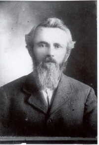
William Edward Owings was born 1855 in Roane Co., TN. He married Leona Akin 1878 in Grayson Co., TX. About 1888 the Owings family settled at Grady in the Chickasaw Nation just north of Spanish Fort, TX Photo by JanePetralliWetzel
|
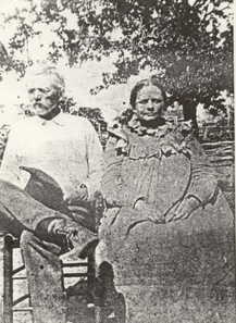
Owings Ferry operators Ed and Leona Owings, Grady ca. 19teens. Leona died in 1920 followed by Ed in 1925. Both are buried in the Grady Cem. Photo by JanePetralliWetzel
|